AI Climate: A Decision Making Tool for Climate Resilience: USING AI TO IDENTIFY CLIMATE CHANGE HAZARDS IN THE CITIES OF THE GLOBAL SOUTH
AI Climate Platform is a land management and decision-making tool geared to Global South cities that lack local data. Its objective is to use advanced Artificial Intelligence (AI) techniques and freely available satellite images to cut the time and expense involved in mapping, monitoring, and predicting exposure to shocks and stresses in fast urbanizing smaller cities of the Global South.
Our ongoing development effort for AI Climate uses data from Tegucigalpa and San Pedro Sula, the two largest urban areas in Honduras, Central America. Climate change in Honduras is increasing the frequency and strength of tropical storms and hurricanes, impoverishing farmers and pushing them to settle in informal urban settlements, which are also at risk from climate change. AI Climate builds on a long record of innovative technology use at I2UD, such as our pioneering use of remote sensing and machine learning in Arusha, Tanzania, in 2013.
Our technical partner, Dymaxion Labs, has garnered extensive experience in applying AI to remote sensing—recognizing patterns in satellite and aerial images—since its founding a few years ago in Buenos Aires, Argentina. Dymaxion Labs is incrementally developing tools to account for hazards ranging from flooding to heat islands and the location of socially vulnerable communities in Honduras.
AI Climate is conceived as a platform that will offer an integrated tool to identify significant risks from climate change affecting poor urban communities. I2UD’s AI-Climate Platform is a response to two significant trends:
➤ The combination of impacts of climate change, fast expansion of informal settlements, and budgetary and trained-personnel limitations
➤ Rapidly increasing geospatial imagery availability and falling processing costs
Press Update – 10/20/2022:
“Planet Launches Nonprofit Program to Empower Mission-Driven Organizations with More Access to Timely, Global Satellite Data”
Planet is putting together a new, standardized program aimed at providing significant amounts of highly discounted imagery to NGOs and nonprofits. The launch of Planet’s Nonprofit Program will feature the collaboration with I2UD and Dymaxion Labs have been doing with mapping informal settlements in Honduras using PlanetScope imagery.
[Excerpt:] “In line with Planet’s mission to use space to help life on Earth and in effort to enable more impactful uses of Planet’s data, the offering addresses two traditional challenges facing nonprofits – limited budgets and resources, and the infrastructure and technical expertise to analyze the data. The goal is that by providing more accessible data products and technical support services, the Nonprofit Program will help users better extract information and create applications that power decisions and enable action.”
“The work I2UD completed [is in] collaboration with Dymaxion Labs, Habitat for Humanity Honduras, GOAL Honduras, and the Honduran Institute of Earth Sciences (IHCIT), in partnership with the Data and Society Accelerator Program from the Patrick J. McGovern Foundation, which introduced Planet to I2UD.”
“The team improved and evolved a land management and decision-making tool geared to Global South secondary and tertiary cities that lack quality and up-to-date local data to monitor exposure of informal settlements and low-income communities to severe and extreme weather impacts. The tool, AI Climate, processes geospatial images and geo-referenced datasets and derives analytics-ready layers of impacts associated with climate change. I2UD is improving and developing layers to identify flooding and landslide risks, informal urbanization, and land value differentials.”
“By using PlanetScope basemaps, I2UD and its partners were able to map vulnerable communities in Tegucigalpa and Sula Valley in Honduras. Compared to previous satellite data platforms, the project analysts found PlanetScope basemaps performed significantly better in both geographies based on intersection of ground truth (IoGT) data, with fewer noisy predictions, and a bigger size of image could be fed into the neural network.”
“Since both climate change and socially vulnerable communities, including informal settlements, are moving targets, it is imperative to aim for speed and frequent updates to make risk information available to those communities as well as planners and policy makers in fast-urbanizing cities; our goal is to use just enough information to keep AI Climate economical and agile but still with good quality prediction,” said Alejandra Mortarini, Vice President, I2UD.”
“An essential part of the I2UD AI Climate platform is to incorporate local partners and communities’ knowledge of their own conditions to ensure that community organizations can make sense of the platform’s findings, and are able to use those outcomes for their own benefit. “The combination of Planet’s higher resolution images, AI technology, and ground truth provided by local partners create a powerful tool for effective city resiliency co-production,” Alfredo Stein, University of Manchester, UK, Senior Advisor to AI Climate, explained.”
“That is why Planet’s imagery was key in providing higher resolution to better create local data for local partners,” Carlos Rufin, President, I2UD, continued. “The cost of higher-resolution imagery is typically unattainable for nonprofits. By providing highly discounted imagery to NGOs and nonprofits, Planet could make a difference in so many dimensions.”
______________
This initiative is a response to two significant trends: On the one hand, the combination of impacts of climate change, fast expansion of informal settlements, and budgetary and trained-personnel limitations, especially in secondary and smaller cities; and on the other, rapidly increasing geospatial imagery availability and falling processing costs, which make it possible to cut time, expense and improve quality of documentation to craft policies, spatial plans, and interventions aiming at safer, resilient cities.
Community involvement is a crucial need in contexts of the limited capacity of local governments to produce relevant data and address local hazards. AI Climate also incorporates a community inclusion, validation, and mapping processes, to integrate local knowledge and to help communities make sense of AI results and put them to use effectively.
In 2020, we received seed money from I2UD Board Member Sherif Lotfi to start a Proof of Concept of the AI Climate tool. At present, a $10,000 in-kind grant from Microsoft’s AI for Earth Program, and a $100,000 Accelerator Grant from the Patrick J. McGovern Foundation, are allowing us to improve and develop capabilities to identify flooding and landslide risks, informal urbanization, and land value differentials. Our vision is that AI Climate will help plan strategies for climate change adaptation and mitigation in cities through participatory processes that include free, equitable access to the tool.
Technically, AI Climate processes geospatial images and geo-referenced datasets and derives analytics-ready layers of climate impacts such as flooding and landslides. Our methodology for developing AI Climate is based on supervised learning techniques, combining the availability of global and local data to calibrate the precision of the models regarding the different data sources and their acquisition cost. All software involved is open source to ensure that the AI Climate Platform is widely accessible to many cities and communities in the Global South that lack the resources to carry out regular and comprehensive hazard identification.
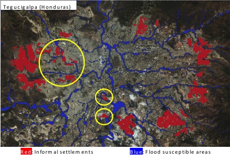
To illustrate how AI Climate works, the image below provides a synthesized graphic of our current development effort’s first round of predictions. It shows a section of Tegucigalpa with the actual areas of socially vulnerable communities we have identified (“ground truth annotations”), the actual communities identified by our algorithms “prediction results”, and also our flooding risk prediction results.
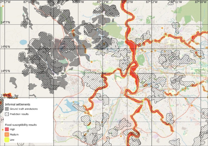
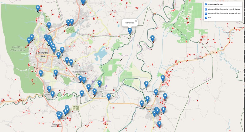
To find the “ground truth” that we need for the machine learning process underlying AI, we work closely with partner organizations in Honduras. The image below shows a snapshot of the interactive map of the Honduras San Pedro Sula region we have developed with our partners. The ground truth data input is represented by the blue pins, indicating the presence of socially vulnerable communities. The red polygons denote our initial predictions about the location of these communities. Comparing both indicators facilitates validating our results by local experts and communities.
Additionally, we have sought to use both satellite images in the public domain and higher-resolution images typically available from commercial sources only to improve the quality of our expected outcomes. Given the high cost of the latter, our approach has been to build relationships with commercial suppliers to request philanthropic use of a limited set of their images, given the non-profit nature of our organization and the project objectives.
With the help of the Patrick J. McGovern Foundation, we are working with a major global provider of high resolution satellite images, Planet, which has agreed to include us in their donation program. The Patrick J. McGovern Foundation is a global 21st century philanthropy bridging the frontiers of artificial intelligence, data science, and social impact to create a thriving, equitable and sustainable future for all. The Foundation’s work focuses on bringing together academia, practitioners, and civil society to pursue the potential of AI and data science to address some of the world’s most urgent challenges.
An essential part of our project is to incorporate local communities’ detailed knowledge of their conditions and to ensure that they can make sense of the findings and use them or their benefit. In Honduras, our approach relies on local partners that are well established in that area, produce high-quality work, and understand and value the nature and objectives of AI Climate. These include Habitat for Humanity, GOAL, and the Honduran Institute of Earth Sciences (IHCIT), and technical advisors Alfredo Stein and Carlos Rivas. These organizations’ prior work and long-standing local presence mean that they have strong connections with local communities, which will allow us to verify AI Climate’s predictions at the community level.
In sum, the AI Climate Platform is an exciting new step in the Institute’s long-standing commitment to bringing cutting-edge technology to the most excluded urban communities of the Global South.
Stay tuned as we share further updates on our AI Climate Platform!
Front Media: (World Maps Online), “Satellite composite map of South America in August” (Projection: Lambert Azimuthal Equal Area; Land imagery: NASA’s MODIS; Ocean bathymetric: GEBCO.)
Accessed 2022 for Educational/Creative Commons Use from: Worldmapsonline.com, “South America Satellite Image Map – Topography & Bathymetry. Code: 1W-SA2-SAT1. Link: https://www.worldmapsonline.com/south-america-satellite-image-map/.